

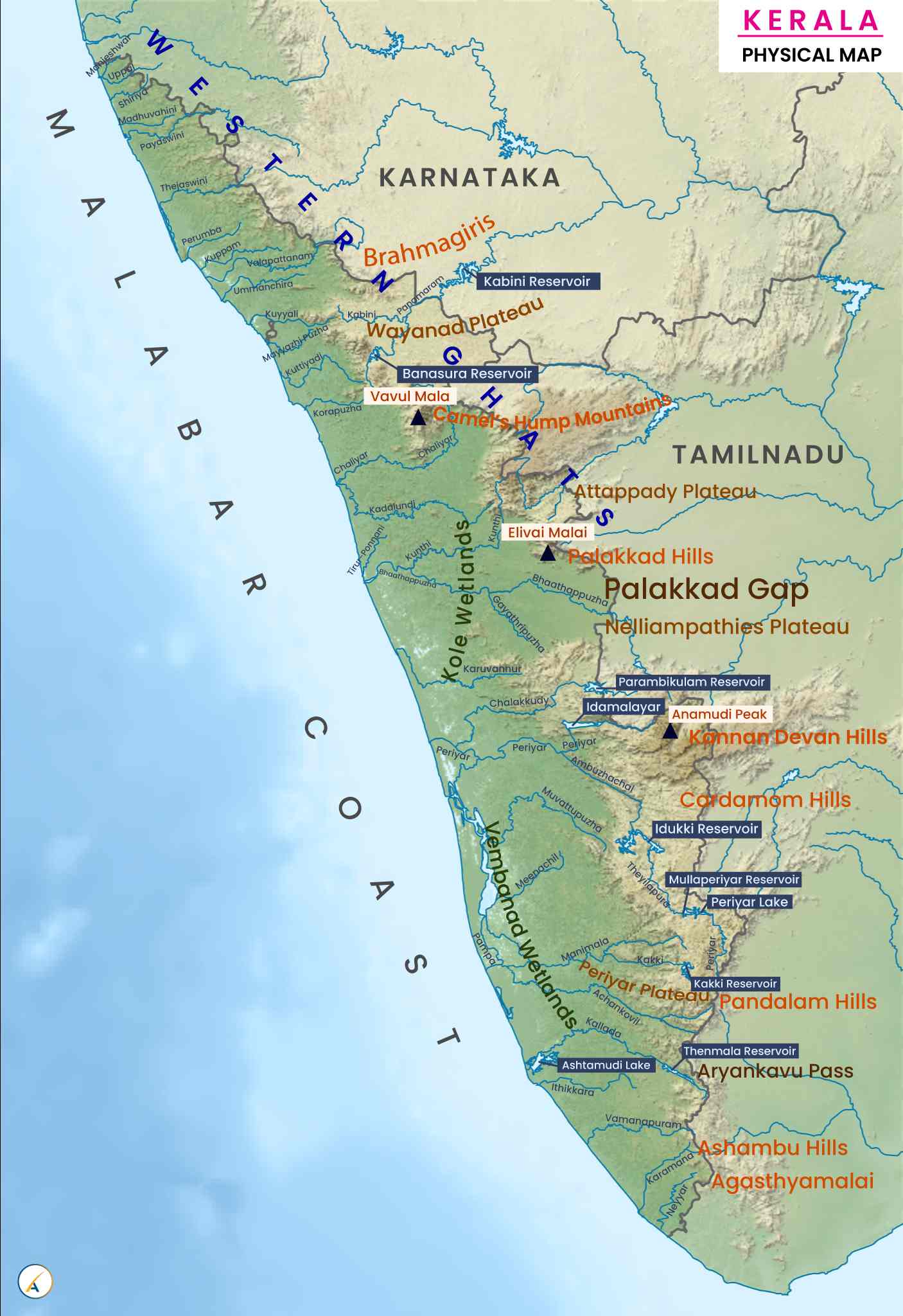
Kerala, located in the southwestern part of India, is famous for its Western Ghats, Arabian Sea coastline, rivers, lakes, backwaters, forests, waterfalls, and rich biodiversity. This quiz covers Kerala’s physical geography, mountains, rivers, lakes, climate, forests, wildlife, coastal features, and natural resources.
Instructions: Try to answer all 100 questions before checking the answer key at the end. This text-only quiz is suitable for students, competitive examinations, school quizzes, and general knowledge enthusiasts.
Part 1: Basic Geography of Kerala
- In which part of India is Kerala located?
- Which sea lies to the west of Kerala?
- Which mountain range forms the eastern highlands of Kerala?
- How many districts are there in Kerala?
- What is the capital of Kerala?
- What is the approximate geographical area of Kerala in square kilometres?
- Which Indian states share land boundaries with Kerala?
- Which is the northernmost district of Kerala?
- Which is the southernmost district of Kerala?
- Which is the largest district in Kerala by area?
- Which is the smallest district in Kerala by area?
- What is the approximate length of Kerala’s coastline?
- Which geographical region of Kerala lies between the coastal plains and the Western Ghats?
- What are the three major geographical divisions of Kerala?
- Which Indian state lies immediately east of much of Kerala’s territory?
Part 2: Mountains and Hill Stations
- What is the highest peak in Kerala?
- What is the approximate height of Anamudi above sea level?
- In which district is Anamudi located?
- Which mountain range contains Anamudi?
- Which famous Kerala hill station is known for its tea plantations and cool climate?
- In which district is Munnar located?
- Which hill station in Thiruvananthapuram district is famous for its misty climate and forests?
- In which district is Vagamon hill station located?
- Which hill destination in Kasaragod district is known for its grasslands and scenic hills?
- Which mountain pass connects Kerala with Tamil Nadu near Palakkad?
- What is the name of the famous hill range associated with the Silent Valley region?
- Which peak in the Western Ghats is famous for its distinctive shape and trekking routes in Wayanad?
- Which district is home to the Chembra Peak trekking destination?
- Which mountain range is recognised as a UNESCO World Heritage Site and extends along Kerala’s eastern side?
- Which hill station near Kozhikode is famous for its forested hills and waterfalls?
Part 3: Rivers of Kerala
- How many rivers are commonly counted in Kerala, including its 44 major rivers?
- Which is the longest river in Kerala?
- What is the approximate length of the Periyar River?
- Which river is popularly known as the lifeline of Kerala?
- Which is the second-longest river in Kerala?
- Which river flows through the Palakkad region and is also known as the Ponnani River in its lower reaches?
- Which river is associated with the famous Aranmula Vallamkali boat race?
- Which river flows through Kozhikode district and is associated with the Beypore region?
- Which river flows through the Wayanad region and is a tributary of the Kabini River?
- Which river forms part of the border between Kerala and Tamil Nadu in the southern region?
- Which river flows through Thrissur district and is associated with the Athirappilly Waterfalls?
- Which river is associated with the Idukki hydroelectric project?
- Which river flows through the Kollam region and is associated with the Kallada irrigation project?
- Which river flows through Kannur district and empties into the Arabian Sea near the Dharmadam region?
- In which direction do most rivers of Kerala flow before reaching the sea?
Part 4: Lakes, Backwaters and Dams
- Which is the largest lake in Kerala?
- Which is the largest freshwater lake in Kerala?
- In which district is Sasthamkotta Lake located?
- Which lake is famous for the Nehru Trophy Boat Race?
- Which lake is associated with the Kumarakom tourist destination?
- Which lake is famous for its eight-shaped appearance and lies in the Idukki region?
- Which lake in Kollam is famous for its scenic backwaters and waterways?
- Which lake forms an important part of the Vembanad-Kol wetland system?
- Which dam in Kerala is one of the highest arch dams in Asia?
- On which river is the Idukki Dam built?
- Which dam is associated with the Malampuzha Gardens?
- In which district is the Mullaperiyar Dam located?
- Which reservoir is associated with the Parambikulam-Aliyar Project?
- Which dam on the Periyar River is associated with the famous Idukki hydroelectric project?
- What is the name of the major irrigation project associated with the Bharathapuzha River?
Part 5: Coastal Geography and Beaches
- Which famous beach in Kerala is associated with Vasco da Gama’s arrival in 1498?
- In which district is Kovalam Beach located?
- Which beach in Kannur district is famous as one of India’s drive-in beaches?
- Which beach in Thiruvananthapuram district is known for its dramatic cliffs?
- Which coastal district is famous for the fishing harbour at Neendakara?
- Which Kerala port city is known for its natural harbour and historic maritime trade?
- Which coastal town is famous for the Beypore shipbuilding tradition?
- What is the traditional wooden sailing vessel built in Kerala called?
- Which district is famous for the historic Bekal Fort overlooking the Arabian Sea?
- Which coastal feature is formed when seawater enters inland through narrow channels and lagoons?
- Which district is associated with the coastal town of Ponnani?
- What is the name of the major port located on Willingdon Island and in the Kochi harbour area?
- Which coastal district is famous for the Alappuzha backwater network?
- Which sea route historically connected Kerala’s spice trade with Arabia and East Africa?
- Which district is home to the coastal town of Munambam?
Part 6: Forests, National Parks and Wildlife
- Which national park in Kerala is famous for the Nilgiri tahr?
- In which district is Silent Valley National Park located?
- Which wildlife sanctuary is famous for elephants and tigers in the Thekkady region?
- In which district is the Wayanad Wildlife Sanctuary located?
- Which tiger reserve includes the Periyar Wildlife Sanctuary?
- Which national park is known for evergreen forests and lion-tailed macaques?
- Which wildlife reserve in Kerala is associated with the Parambikulam Tiger Reserve?
- Which biosphere reserve includes parts of Kerala, Tamil Nadu, and Karnataka?
- Which national park is located in the high ranges near Munnar?
- Which Kerala bird sanctuary is located near Vembanad Lake in Kottayam district?
- Which forest region of Kerala is especially famous for its tropical evergreen vegetation and high biodiversity?
- Which rare flowering plant blooms in parts of the Western Ghats at intervals of around 12 years?
- Which endangered mountain goat is protected in Eravikulam National Park?
- Which island in the Kabini River region of Wayanad is famous for its rich biodiversity?
- Which Kerala district is particularly associated with the Agasthyamala Biosphere Reserve?
Part 7: Climate, Agriculture and Natural Resources
- Which type of climate is generally experienced by Kerala?
- Which monsoon brings the major share of Kerala’s annual rainfall?
- During which months does the southwest monsoon usually affect Kerala?
- Which natural geographical feature contributes significantly to the heavy rainfall on Kerala’s western slopes?
- Which agricultural crop is Kerala particularly famous for cultivating in its high ranges?
- Which plantation crop is widely cultivated in the Wayanad region?
- Which mineral resource has historically been mined along the Chavara coast?
- Which coastal district is famous for deposits of mineral-rich beach sands, including ilmenite and monazite?
- Which agricultural crop is traditionally associated with Kerala’s coastal plains and lowlands?
- Why is Kerala often called “God’s Own Country” in tourism campaigns?
Answer Key: 100 GK Questions About Kerala Geography
- Southwestern India
- Arabian Sea
- Western Ghats
- 14
- Thiruvananthapuram
- Approximately 38,863 square kilometres
- Karnataka and Tamil Nadu
- Kasaragod
- Thiruvananthapuram
- Palakkad
- Alappuzha
- Approximately 590 kilometres
- The midlands
- Lowlands, midlands, and highlands
- Tamil Nadu
- Anamudi
- Approximately 2,695 metres
- Idukki
- Western Ghats
- Munnar
- Idukki
- Ponmudi
- Mainly Idukki and Kottayam districts; the hill region extends across their boundary
- Ranipuram
- Palakkad Gap
- Nilgiri Hills and the adjoining Western Ghats ranges
- Chembra Peak
- Wayanad
- Western Ghats
- Thusharagiri
- 44 rivers
- Periyar River
- Approximately 244 kilometres
- Periyar River
- Bharathapuzha River
- Bharathapuzha River
- Pamba River
- Chaliyar River
- Kabini River
- Neyyar River
- Chalakudy River
- Periyar River
- Kallada River
- Anjarakandy River
- Generally westward, towards the Arabian Sea
- Vembanad Lake
- Sasthamkotta Lake
- Kollam
- Punnamada Lake
- Vembanad Lake
- Idukki Reservoir
- Ashtamudi Lake
- Vembanad Lake
- Idukki Arch Dam
- Periyar River
- Malampuzha Dam
- Idukki district, near the Kerala–Tamil Nadu boundary
- Parambikulam Reservoir
- Idukki Arch Dam is built across the Periyar River system
- Malampuzha Irrigation Project
- Kappad Beach
- Thiruvananthapuram
- Muzhappilangad Drive-in Beach
- Varkala Beach
- Kollam
- Kochi
- Beypore
- Uru
- Kasaragod
- Backwater or lagoon
- Malappuram
- Cochin Port
- Alappuzha
- The Indian Ocean maritime trade routes
- Ernakulam
- Eravikulam National Park
- Palakkad
- Periyar Wildlife Sanctuary
- Wayanad
- Periyar Tiger Reserve
- Silent Valley National Park
- Parambikulam Tiger Reserve
- Nilgiri Biosphere Reserve
- Eravikulam National Park
- Kumarakom Bird Sanctuary
- The Western Ghats
- Neelakurinji
- Nilgiri tahr
- Kuruva Island
- Thiruvananthapuram
- Tropical monsoon climate
- Southwest monsoon
- June to September
- The Western Ghats
- Tea
- Coffee
- Mineral-rich beach sand, especially ilmenite
- Kollam
- Coconut and rice
- Its natural beauty, including beaches, backwaters, mountains, forests, and rich cultural heritage
Note: River lengths, coastline measurements, and geographical classifications can vary slightly between official sources and measurement methods. For examination preparation, use the figures prescribed by the relevant syllabus or official reference material.
Leave a Reply